Configuration file
Bridge has a configuration file that can be used to configure a number of options. To use the Bridge configuration file, in the Bridge intstallation directory copy the bridge.config.template file to bridge.config. The default installation directory of Bridge is either C:\Program Files\GeoCat\Bridge 2 or C:\Program Files (x86)\GeoCat\Bridge 2 depending on whether the OS is 32 or 64 bits. Removing the bridge.config will restore the default configuration settings.
ArcLayerNameAsOWSTitle
Use the layername in TOC of ArcMap as the OWS layer/featuretype/coverage title in GeoServer/MapServer, instead of using the metadata title of the dataset of the layer.
Allowed values:
Default value:
<add key="ArcLayerNameAsOWSTitle" value="False"/>
BasicAuthenticationGeoServer
Set Bridge to use basic authentication to connect to GeoServer. By default Bridge uses form authentication with a JSESSIONID cookie.
Allowed values:
Default value:
<add key="BasicAuthenticationGeoServer" value="False"/>
CopyFontsMapServer
Copy fonts of symbology to MapServer on publication. Be aware that you need to have a valid license to use some proprietary fonts on your MapServer. For instance it is not allowed to use ESRI fonts on a server that is not running any licensed ESRI products.
When using an ftp service to copy the fonts to your server you will need to either:
- create an alias named
_bridge_fonts_ in the home folder of the ftp user that points to the MapServer fonts folder (FileZilla Server on Windows)
- create a directory named
_bridge_fonts_ in the home folder of the ftp user and mount the MapServer fonts folder on it like this:
Creating a directory named _bridge_fonts_ is not required when copying the files to the local filesystem.
mkdir /mapserver/projects/_bridge_fonts_
mount --bind /mapserver/fonts /mapserver/projects/_bridge_fonts_
When copying of the files fails, no error message is displayed in the publish report afterwards, this will be improved in a later version. Check the log file for error messages on copying the fonts.
Allowed values:
Default value:
<add key="CopyFontsMapServer" value="False"/>
CustomDownloadProtocols
Set specific protocol string for format specific download links, see AddDownloadLinksMetadata. Comma separated list of key value pair. Key and value should be separated by %. The key GML sets the download format for all GML formats (GML2,GML3.1,GML3.2).
Allowed keys: CSV,``GML``,``GML2``,``GML3.1``,``GML3.2``,``GeoJSON``,``KML``,``Shapefile``,``geopackage``,``geotiff``.
Example usage:
<add key="CustomDownloadProtocols" value="GeoJSON%JSON,KML%OGC:KML"/>
Default value:
<add key="CustomDownloadProtocols" value=""/>
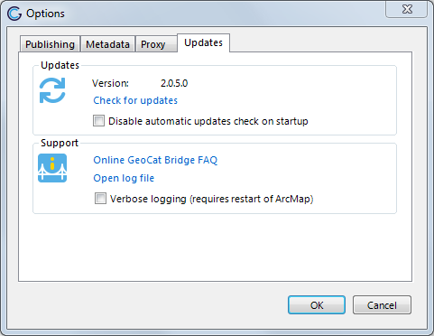
DisableUpdater
Disable automatic checking for updates
Allowed values:
Default value:
<add key="DisableUpdater" value="False"/>
Expect100Continue
Adds HTTP header Expect: 100-Continue to all HTTP requests
Allowed values:
Default value:
<add key="Expect100Continue" value="True"/>
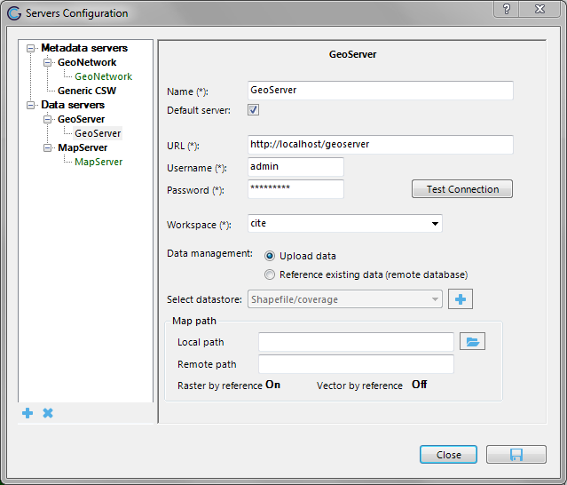
FileRasterByReference
Publish raster data by reference to GeoServer. Prevents uploading raster files to GeoServer, requires the raster files to be accessible from both ArcMap and GeoServer. When this option is enabled and additional configuration option “Map path” is shown in the GeoServer configuration panel. Supported file formats are GeoTiff,WorldImage, ECW and ImageMosaic.
The map path option allows to configure a mapping between from the local path to the remote path. For instance when the raster data is available for ArcMap in D:\rasters and for GeoServer in Z:\rasters the value for local path is D:\ and the value for remote path is Z:\.
Allowed values:
Default value:
<add key="FileRasterByReference" value="False"/>
FileVectorByReference
Publish shapefiles by reference to GeoServer. Prevents uploading vector files to GeoServer, requires the shapefiles to be accessible from both ArcMap and GeoServer. When this option is enabled and additional configuration option “Map path” is shown in the GeoServer configuration panel. See the FileRasterByReference option for a screenshot. Shapefile only, so does not work for any geodatabase (FGDB, PGDB, etc.)
The map path option allows to configure a mapping between from the local path to the remote path. For instance when the vector data is available for ArcMap in D:\vectors and for GeoServer in Z:\vectors the value for local path is D:\ and the value for remote path is Z:\.
Allowed values:
Default value:
<add key="FileVectorByReference" value="False"/>
ForceGeoTiffDatastore
Always use a GeoTiff datastore when creating raster layers in GeoServer, instead of creating a WorldImage datastore when the raster file has world file. Should not be used when FileRasterByReference is not enabled. Other requirement is that GeoTiffs that are published should have set the projection authority in the projection string of the GeoTiff. The GeoTiff should not be georeferenced by a custom CRS. Check with GDALINFO tool if this is the case, see the gdal website for more information. Use the gdal_edit.py utility to set the projection authority in the projection string of the GeoTiff gdal_edit.py -a_srs EPSG:<CODE> <FILEPATH>.
Allowed values:
Default value:
<add key="ForceGeoTiffDatastore" value="False"/>
ForceShapefile
Use Shapefile format even if the GeoPackage extension is installed in GeoServer.
Allowed values:
Default value:
<add key="ForceShapefile" value="False"/>
HTTPUserAgent
Sets a user-agent string for all HTTP requests. Default value is an empty string. In case you need to specify a user-agent a recommended value is geocat-bridge.
Allowed values:
- Any string made out of the following character set [a-zA-Z0-9]
Default value:
<add key="HTTPUserAgent" value=""/>
KeepExistingDistOnPublication
On publication of metadata to catalogue keep all online resources referenced in the metadata. When set to False Bridge will remove all the online resources referenced in the metadata and only add the online resources for the current publication.
Allowed values:
Default value:
<add key="KeepExistingDistOnPublication" value="False"/>
LayerGroupMode
Default mode for layer groups created in GeoServer, valid values are CONTAINER, SINGLE and NAMED.
Allowed values:
Default value:
<add key="LayerGroupMode" value="CONTAINER"/>
LowerCasePostGIS
When set to true Bridge will create lower case tables in PostGIS with lowercase column names and create layers with lowercase layernames in OWS services in GeoServer. Recommended to set to True, default value is set to False for backwards compatibility.
Allowed values:
Default value:
<add key="LowerCasePostGIS" value="False"/>
ManagedWorkspacesMode
When this option is turned on, Bridge will manage about the workspaces in GeoServer by enforcing a one to one relationship between ESRI map documents (.mxd or .lyr files) and workspaces. When publishing a mapdocument_a.mxd with layer layer_a and layer_b, bridge will create a new workspace mapdocument_a in GeoServer and publish both layers in this workspace. When necessary Bridge will also copy over the required datastore to the newly created workspace mapdocument_a.
Allowed values:
Default value:
<add key="ManagedWorkspacesMode" value="False"/>
MapfileMAXSIZE
Set MAXSIZE for MapServer mapfile, when set to 0 Bridge will not specify MAXSIZE. In that case MapServer uses the default as MAXSIZE (2048px).
Allowed values:
- Any positive integer value
Default value:
<add key="MapfileMAXSIZE" value="2048"/>
MarginExtent
Sets a margin on the bounding box of the Mapfile or the bounding box of the layer (GeoServer). Value is a percentage of the layer or map extent.
Allowed values:
- Any positive decimal value
Default value:
<add key="MarginExtent" value="0.05"/>
OwsAccessConstraints
Set default value for access constraints in OWS capabilities document (GeoServer only), when empty Bridge will not configure this value for new workspaces and therefore the value from /rest/services/wms/settings.xml will configure this value.
Allowed values:
Default value:
<add key="OwsAccessConstraints" value=""/>
OwsFees
Set default value for fees in OWS capabilities document (GeoServer only), when empty Bridge will not configure this value for new workspaces and therefore the value from /rest/services/wms/settings.xml will configure this value.
Allowed values:
Default value:
<add key="OwsFees" value=""/>
ReverseWMSLayers
Reverse layers in WMS service workspace/mapfile. By default Bridge organises the layers in the WMS based on drawing order. So the top layer (in your ArcMap map project) will be the last layer in the WMS capabilities document. If you want the top layer (in your ArcMap map project) to be the first layer in the WMS capabilities document, set the ReverseWMSLayers configuration option to True.
Allowed values:
<add key="ReverseWMSLayers" value="False"/>
SymbolSizeFactor
Multiply symbol size for MapServer mapfile with this factor
Allowed values:
- Any decimal value (decimal separator ”.”)
Default value:
<add key="SymbolSizeFactor" value="1.0"/>
TruncateFieldNameWhenPublishingOffline
Truncate field names when publishing offline
Allowed values:
Default value:
<add key="TruncateFieldNameWhenPublishingOffline" value="False"/>
Administrator configuration
The configuration and the server connections of Bridge are saved in a SQLite database in the local application data folder called arcgis_publisher.s3db. The local application data folder can be found under (substitute the USER with the actual user name): C:\Users\USER\AppData\Local\GeoCat\Bridge 2.
This file can be used as a configuration file for deploying Bridge on a large number of machines. Simply configure Bridge on one machine and retrieve arcgis_publisher.s3db and use this file to configure other installations.
An empty configuration database can be found in the Bridge installation folder. The Bridge installation folder is typically located in C:\Program Files\GeoCat\Bridge 2 (32 bits OS) or C:\Program Files (x86)\GeoCat\Bridge 2 (64 bits OS). The empty database can be used to reset the existing configuration, by replacing the file in the local application data folder with the one from the installation folder.
Password Encryption
Note that the passwords for all the server configurations are encrypted inside the GeoCat Bridge configuration database.
 Manual
2.5
Manual
2.5