14. Bridge Behaviour
Naming
The following section is both valid for GeoServer and MapServer. Replace GeoServer with MapServer and ignore the part about the datastore for MapServer.
When publishing data to GeoServer Bridge uses the following naming convention:
- The ArcMap layer name is used for the GeoServer layer name, for this the ArcMap layer name is escaped to make it a valid WMS/WFS/WCS layer name (replacing spaces with underscores, replacing special characters with underscores)
- The ArcMap layer name is used for the GeoServer layer title. There is also the option to use the metadata title of the layer, configure this by setting
MetadataTitleAsOWSTitleconfiguration parameter, see MetadataTitleAsOWSTitle - When using a file based datastore (such as Shapefile, GeoPackage or GeoTiff) in GeoServer the name of the datastore will be set to the escaped ArcMap layer name
- The filename of the exported file (Shapefile, GeoPackage or GeoTiff) will be set to the escaped ArcMap layer name
note:: Bridge does not use the name of the original dataset on the server. The reason is that users can decide to apply a filter on a dataset, so each layer is published as a new dataset to the map server (this not the case when publishing by reference to an Oracle or ArcSDE datastore in GeoServer). This can potentially duplicate the data on your server, if you are creating multiple layers based upon the same data set.
| Name on the server | Names in ArcGIS |
|---|---|
| WMS/WFS layer name | Layer name (escaped) |
| WMS/WFS layer title | Metadata title of dataset |
| Exported filename | Layer name (escaped) |
| Datastore name (only file based) | Layer name (escaped) |
Example
We have a layer named “States US” . When the layer “States US” is published to GeoServer in a Shapefile datastore this will be the result:
| Type | Name |
|---|---|
| GS layer name | States_US |
| GS layer title | States US |
| Datastore name | States_US |
| Shapefile name | States_US |
Publication
File base data formats
GeoServer
When publishing your data to GeoServer, Bridge uses the GeoPackage format by default, when GeoPackage format is supported by GeoServer. See also GeoPackage. When Bridge detects that GeoServer is not supporting GeoPackage, Bridge will use Shapefile as the transport format. The advantage of using GeoPackage over Shapefile is that GeoPackage does not have a limit on the field name length, as is the case with Shapefiles (maximum field name length is 10 characters).
If you prefer to use Shapefile as the transport format, you can set the following ForceShapefile configuration option in the Bridge configuration file to false, see ForceShapefile.
Using GeoPackage you can either publish your data to a Filebased datastore or to a PostGIS datastore. When choosing a Filebased datastore Bridge will create a new GeoPackage datastore for each layer that you publish. When choosing a PostGIS datastore Bridge will upload the data to GeoServer through a GeoPackage file. GeoServer in turn will make sure that the uploaded data is inserted in the PostGIS database.
MapServer
When publishing your data to MapServer Bridge by default publishes the data as a Shapefile in MapServer. Bridge can also store the data as a GeoPackage. To enable this set the Use GeoPackage option to On in the Data settings tab of the MapServer connection.
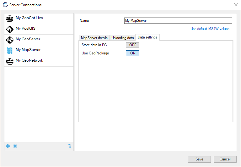
MapServer store data as GeoPackage
Managed workspace mode
General behaviour
Managed Workspace is a configuration specifically targeting publication to GeoServer. When managed workspace mode is enabled Bridge will enforce a one to one relationship between ESRI map documents (MXD) and GeoServer workspaces. So for each new map document you publish, Bridge will create a new workspace in GeoServer. If necessary Bridge will also copy over datastore configured necessary for publishing your project. This way your services are immediately neatly organized and each map has it own service endpoint.
Datastores
When managed workspace mode is enabled, the GeoServer configuration window will still require to fill out the workspace. This workspace is only used so you can select the datastore you want to publish to. If you select a PostGIS or OracleSpatial datastore then when creating a new workspace Bridge will copy over the datastore definition from the the workspace you selected the datastore in to the new workspace. When selecting the option file-based datastore, then the workspace setting for that server has no effect.
Support for layer groups
Only with managed workspace enabled Bridge supports layer groups or when publishing to MapServer. By default Bridge creates layer groups in GeoServer of type CONTAINER. You can configure the type of layer groups in the Bridge configuration file, see LayerGroupMode.
Bridge also takes care of setting the title and abstract of the layer group in GeoServer, to the title and abstract of the layer group in the ArcMap map project.
Modifying your published project
With the managed workspace mode Bridge is ensuring a one to one mapping between the ESRI map document and the GeoServer workspace. On publication Bridge will perform a one-way sync of the layers towards GeoServer. This means that any layers that are present in the GeoServer workspace that are not present in the MXD will be deleted from the GeoServer workspace.
Due to the one to one relationship between MXD and GeoServer Bridge has no option to selectively publish layers from your mxd as provided in the regular mode. Nor does it provide the option to remove a single layer from the workspace. If you want to control what is published you will have to modify your map project (MXD) and remove a layer from your project.
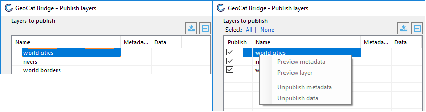
Publish wizard in managed workspace mode (left) and in regular mode (right)
Metadata for new workspaces
When Bridge publishes an ESRI map document it will create a new workspace, if it did not exist yet. After creating the workspace Bridge will also update some of the metadata fields of the new workspace. These fields will be visible in the capabilities document of the different OGC services.
The metadata fields are taken from the map document properties:
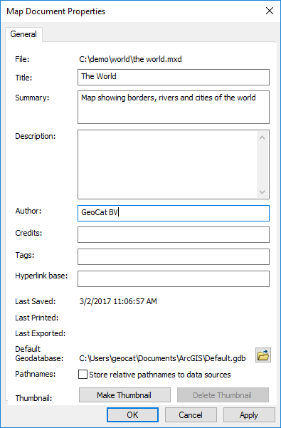
Map document properties
And from the data frame properties:
Data frame properties
See the table below for the mapping between the ESRI metadata fields and the GeoServer metadata fields:
| Metadata in Bridge | Metadata in GeoServer |
|---|---|
| Title map document properties | Title in workspace specific service settings for WMS |
| Description map document properties (if description is empty, summary is taken) | Abstract in workspace specific service settings for WMS |
| Tags map document properties | Keywords in workspace specific service settings for WMS |
| Author map document properties | Organization in primary contact in workspace specific settings (overriding the global default contact settings) |
| Title data frame properties | Title of root layer info in workspace specific service settings for WMS |
| Abstract data frame properties | Abstract of root layer info in workspace specific service settings for WMS |
| OwsFees from Bridge.config file | Fees in workspace specific service settings for WMS (if OwsFees from Bridge.config file is filled, otherwise fees configuration from global workspace settings in GeoServer takes effect) |
| OwsAccessConstraints from Bridge.config file | AccessConstraints in workspace specific service settings for WMS (if OwsAccessConstraints from Bridge.config file is filled, otherwise AccessConstraints configuration from global workspace settings in GeoServer takes effect) |
Multiple styles per layer
Bridge supports multiple styles per layer, but only for GeoServer. When your map project contains multiple layers based on the same source data, Bridge detects this and enables the “Manage styles” context menu item in the publish window. Note that the layers based on the same data source need to be all in the same layer group or in the root of the map project and a GeoServer connection needs to be selected.
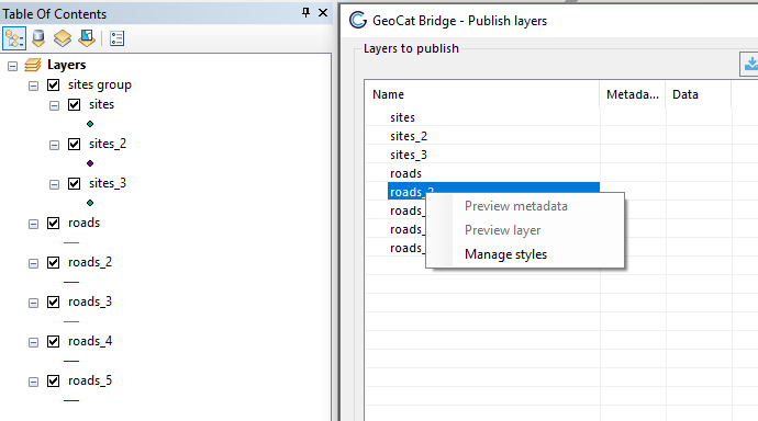
Multiple styles context menu
Clicking on then “Manage styles” item brings up the “Manage styles” menu. The menu only shows layers that have a common data source and the layers are grouped per data source. Checking the “Publish as separate styles” checkbox, will publish those layers as one layer. The layer that is checked in the list will be published as the default style for that layer. The other layers will be published as optional styles. The name of the style in GeoServer will be the escaped layer name (spaces are replaced with underscores and special characters are stripped).
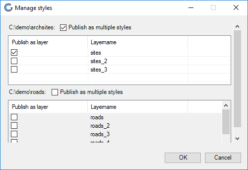
Multiple styles menu
After selecting layers to be published as multiple styles Bridge remove the layers published as styles from the publish window. Disabling the “Publish as multiple styles” will add the layers again to the publish window.
Bridge saves the multiple styles settings to disk, so when you open your map project after closing it will automatically apply the settings from your previous session. Unless you have renamed or moved some of the layers to a different group layer.